Directions |
Features of Interest |
Walk along drive, turn left on to the lane, continue downhill and pass the first house on the left at the junction. |
On the left hand side of the drive there are light green blade-like leaves of Crocosmia (Montbretia) which has orange flowers in Aug-Sept. Not a native species but frequently found in this area. The view to the left of the drive is towards the triangular shaped mountain Croagh Patrick. To the right of the drive is the stream which used to have a pipe in it supplying the cottage from the well. Immediately to the left on the lane are snowberry bushes. A little further down the lane you will notice many flowerless plants with thin fronds - "horsetails" (Equisetum) - related to ferns. The hedgerows have many wild flowers. The main tree species along this road are hawthorn, alder and willow. |
Turn left down the lane (ie between the two houses at the junction), pass the first electricity pole but stop several yards before second electricity pole. |
Before the gate to the field on the right, notice the stone wall on the right around a village well. It may be overgrown but you will notice the stream from the well flowing into the field. The field, like many others around this area, tends to be wet. |
Continue along the lane and pass 2 modern houses to the left and two to the right. |
Notice the horse chestnuts planted at the entrance to the first house on the left. The species is non-native and there aren't many growing "wild" in the area, though the council has planted them along some main roads. You can see the view back to the cottage through the distant hedgerow before reaching the second house on the left. The hedgerow is very "gappy" and new trees are being planted along it. The tall pine trees were planted in 1987. After passing the 4 houses notice how the road suddenly deteriorates. No-one lives past this point along the lane. It is part of the "Foxford Way" footpath and serves as access to fields. |
Stop at the red barn to the right before the other farm buildings |
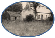
Notice the overgrown box hedge to your left. Look carefully for the hidden gate that led to a garden and house. Walk on a little further and see the abandoned house that had the garden gate. The house has been empty for around 20 years. |
Continue along the lane
|
The track can be muddy in places even in dry weather because there are springs. There is a slight uphill stretch and you will see gorse bushes damaged by the severe cold in winter 2010-11. Also visible along this stretch are heathers. You will reach an area to your right which was burnt in April 2011. Notice bilberry bushes to the left as you reach the end of the first burnt field. The next burnt field is colonised by bracken. You will see a limestone natural wall/cliff to the left which was burnt. It was previously covered with many wildflowers and was a popular resting place for the many butterflies on a sunny day. Now ferns are the first colonisers. As you walk downhill, about half way down keep an eye out for a few butterworts growing in the centre of the lane. The pale green leaves are in rosette form and small - the plant is about 2-3 inches in diameter. Butterwort catches insects on its sticky leaves and digests them. Further down the hill you will probably see a couple of springs in the road. The second one, on the right of the track, flows even in dry weather. You will now reach the lowest point of the lane where the track crosses a stream (not visible, but audible). Continuing uphill you see forestry to the left, some trees burnt April 2011. |
At end of lane turn left on to a "main road" and then immediately right. (ie road forks) and continue along this road. |
Notice the new "Toomore" village sign as you take the right fork. Note the open grazing land to the right and probably sheep rather than cows grazing. As you walk along this road you will see some large new houses to contrast with the small, old farm building to the right (near the electricity pole). The houses were built around 7-10 years ago during the boom times and generally replaced old buildings thus facilitating the granting of planning permission. After passing the new house to the right notice the hedgerow contains rose, honeysuckle and hazel. As you approach the bend to the right notice the line of conifers in the distance to the left - these are near the bog you will be walking through in about 10 minutes. As the road bends right you will see a bungalow that you need to pass. |
Turn left immediately after the bungalow and continue for around 5 minutes. Keep right at the next house on the left (backed by trees) |
The road surface deteriorates again as this road really only goes to the bog and one house. The road firstly goes downhill but when you are walking uphill again look to the view on the left to the ridge of hills and this is where you have walked from. Continue round the next bend (left) and you will start to see the bog. You will pass a house to the left nestling in the trees. There used to be tall trees in front of the house making it really hidden. Now there is a "cottage type" garden in summer. Follow the road to the right at this point. Continuing you will pass some burnt conifers to your left as the bog extends on the right. You are about half way through the walk at this point. |
At junction with another minor road turn left
|
Standing at this little road junction before you turn left, the bog plot belonging to the cottage is to your right and slightly behind you. There are many interesting plant species here, including bog asphodel, bog cotton, heather, orchids and the insectivorous sundew, as well as the sphagnum moss that creates the peat. There is now a ban on certain types of mechanical turf-cutting for conservation reasons but owners can still cut by hand. |
Continue down a rough winding road |
The lane firstly goes downhill and you cross a stone bridge over a stream. There are some newer conifer plantings in this relatively open area. The road climbs up with quite a few bends. Note more hazels in the hedgerow in this area. Pass another conifer plantation to the left and reach a main road which is actually a crossroads. |
Go straight across at the crossroads |
The road you are now on has a little building to the right. This is the pumping station for the water supply to homes in the area, including the cottage. Continue uphill with a forestry plantation to the right and then grazing fields. You are heading for the hills you could see before you reached the bog. |
Take the next turn left and following this road back to the cottage.
|
This lane now leads back to the cottage, though it is still about 15-20 minutes' walk. You will pass a few houses spread out along this road. After about 5 minutes you will pass a new stone sign at road level on the right saying "Cashel" and "Culmore". You are leaving Cashel and entering Culmore. On reaching a point where the road turns to the left you will be at the highest point of the walk. Pass the houses to the left and right as you go down the hill. Ahead you can see wind turbines on the hills at Kiltimagh. To the right there are wind turbines at Castlebar. A little further on you will be able to see Lough Cullen/Conn to your right. Just beyond the ochre coloured house on the right is the well which used to supply the cottage. The entrance to the cottage driveway is now to your left. |